


About
Description
📩 Digital product.
The license key will be delivered by email within 24 hours after purchase.
Transform your work with precise 3D scans and AR
Workflow
Capture ground data
Walk along or around the area of interest to scan, and PIX4Dcatch will automatically record video frames with positional and orientation information.
Ensure completeness
Experience real-time AR feedback on your scan's coverage and completion with a 3D mesh overlay and point cloud live viewer.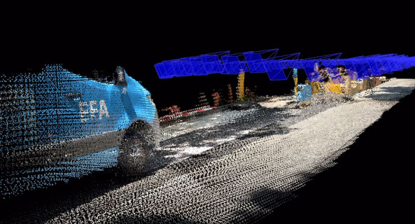
Pause and restart
Pause the capture whenever needed. The live viewer continues to display on your device, displaying the areas you've already covered.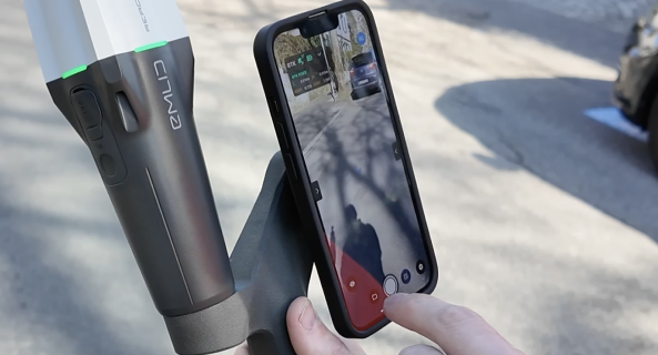
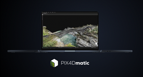
Export and process
Upload the captured images to PIX4Dcloud or export them to PIX4Dmapper or PIX4Dmatic to generate accurate, measurable, and easy to share 3D models and point clouds.
PIX4Dcatch is a mobile app developed by PIX4D, a Swiss-based leader in photogrammetry and drone mapping software. The app allows users to capture georeferenced 3D data using just their mobile device, leveraging LiDAR sensors (on supported iOS devices) or traditional photogrammetry methods using RGB cameras. The result? Accurate 3D models can be processed and analyzed in PIX4D’s ecosystem of tools, like PIX4Dcloud and PIX4Dmapper.
In simple terms, you walk around an object or area with your phone, and PIX4Dcatch collects a series of images and location data to recreate a digital 3D representation. The app guides you in real time, showing the coverage of your scan and alerting you if certain areas need more data.
Why It Matters
3D scanning has historically required specialized equipment—laser scanners, drones, or high-end GNSS receivers—that can cost thousands of dollars. PIX4Dcatch significantly lowers the barrier to entry by putting scanning capability into the hands of anyone with a smartphone or tablet.
This democratization of spatial data capture opens up opportunities across industries:
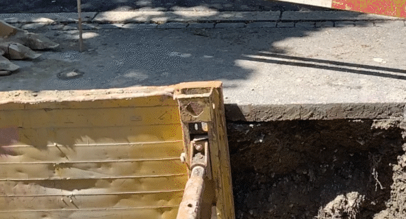
- Construction & Civil Engineering: Capture site conditions before, during, and after work for documentation, progress tracking, and quality control.
- Surveying & Mapping: Generate accurate digital twins of small to medium-sized sites without needing bulky equipment.
- Cultural Heritage & Archaeology: Quickly document historic structures and excavation sites in high detail.
- Insurance & Inspection: Perform damage assessments and inspections without climbing ladders or using drones.
Features That Stand Out
- LiDAR integration: On compatible iPhones and iPads, PIX4Dcatch uses LiDAR to enhance depth perception and accuracy.
- RTK support: When connected to the PIX4D viDoc RTK rover, users can achieve survey-grade accuracy—down to the centimeter level.
- Cloud syncing: Scans can be uploaded directly to PIX4Dcloud for processing, visualization, and sharing with teams.
- Visual Guidance: A real-time display helps users see their coverage and ensures a complete scan.
The Workflow in Action
- Open the app and start a new project.
- Walk around the subject or area, keeping the device stable and letting the app guide your motion.
- Upload the dataset to PIX4Dcloud or export it for processing in tools like PIX4Dmapper or PIX4Dmatic.
- Analyze and share the results—measurements, volumes, annotations, and more.
The process is surprisingly intuitive, and for professionals already using PIX4D tools, the integration feels seamless.
Limitations to Keep in Mind
While PIX4Dcatch is powerful, it’s not without limits. The accuracy of scans can vary depending on the device, environmental conditions (like lighting and texture), and whether or not RTK support is used. Large-scale topographic mapping is still better suited to drones or terrestrial laser scanners.
Final Thoughts
PIX4Dcatch is more than a scanning app—it's a glimpse into the future of accessible 3D data capture. With each hardware and software update, it gets closer to rivaling traditional surveying tools, while remaining exponentially more convenient and affordable.
For anyone working in the AEC industry or spatial data professions, it’s worth exploring how PIX4Dcatch could fit into your workflow. It’s a pocket-sized revolution—quite literally.
Description
📩 Digital product.
The license key will be delivered by email within 24 hours after purchase.
Transform your work with precise 3D scans and AR
Workflow
Capture ground data
Walk along or around the area of interest to scan, and PIX4Dcatch will automatically record video frames with positional and orientation information.
Ensure completeness
Experience real-time AR feedback on your scan's coverage and completion with a 3D mesh overlay and point cloud live viewer.
Pause and restart
Pause the capture whenever needed. The live viewer continues to display on your device, displaying the areas you've already covered.
Export and process
Upload the captured images to PIX4Dcloud or export them to PIX4Dmapper or PIX4Dmatic to generate accurate, measurable, and easy to share 3D models and point clouds.
PIX4Dcatch is a mobile app developed by PIX4D, a Swiss-based leader in photogrammetry and drone mapping software. The app allows users to capture georeferenced 3D data using just their mobile device, leveraging LiDAR sensors (on supported iOS devices) or traditional photogrammetry methods using RGB cameras. The result? Accurate 3D models can be processed and analyzed in PIX4D’s ecosystem of tools, like PIX4Dcloud and PIX4Dmapper.
In simple terms, you walk around an object or area with your phone, and PIX4Dcatch collects a series of images and location data to recreate a digital 3D representation. The app guides you in real time, showing the coverage of your scan and alerting you if certain areas need more data.
Why It Matters
3D scanning has historically required specialized equipment—laser scanners, drones, or high-end GNSS receivers—that can cost thousands of dollars. PIX4Dcatch significantly lowers the barrier to entry by putting scanning capability into the hands of anyone with a smartphone or tablet.
This democratization of spatial data capture opens up opportunities across industries:
- Construction & Civil Engineering: Capture site conditions before, during, and after work for documentation, progress tracking, and quality control.
- Surveying & Mapping: Generate accurate digital twins of small to medium-sized sites without needing bulky equipment.
- Cultural Heritage & Archaeology: Quickly document historic structures and excavation sites in high detail.
- Insurance & Inspection: Perform damage assessments and inspections without climbing ladders or using drones.
Features That Stand Out
- LiDAR integration: On compatible iPhones and iPads, PIX4Dcatch uses LiDAR to enhance depth perception and accuracy.
- RTK support: When connected to the PIX4D viDoc RTK rover, users can achieve survey-grade accuracy—down to the centimeter level.
- Cloud syncing: Scans can be uploaded directly to PIX4Dcloud for processing, visualization, and sharing with teams.
- Visual Guidance: A real-time display helps users see their coverage and ensures a complete scan.
The Workflow in Action
- Open the app and start a new project.
- Walk around the subject or area, keeping the device stable and letting the app guide your motion.
- Upload the dataset to PIX4Dcloud or export it for processing in tools like PIX4Dmapper or PIX4Dmatic.
- Analyze and share the results—measurements, volumes, annotations, and more.
The process is surprisingly intuitive, and for professionals already using PIX4D tools, the integration feels seamless.
Limitations to Keep in Mind
While PIX4Dcatch is powerful, it’s not without limits. The accuracy of scans can vary depending on the device, environmental conditions (like lighting and texture), and whether or not RTK support is used. Large-scale topographic mapping is still better suited to drones or terrestrial laser scanners.
Final Thoughts
PIX4Dcatch is more than a scanning app—it's a glimpse into the future of accessible 3D data capture. With each hardware and software update, it gets closer to rivaling traditional surveying tools, while remaining exponentially more convenient and affordable.
For anyone working in the AEC industry or spatial data professions, it’s worth exploring how PIX4Dcatch could fit into your workflow. It’s a pocket-sized revolution—quite literally.
PIX4D
by
PIX4D
Pix4D PIX4Dcatch Professional Software Subscription License
- Regular price
- $99.5
- Sale price
- $99.5
- Regular price
-
Shipping calculated at checkout.
Providing the best new Tech Experience, Energy Independence and Robotics Ways of Optimisation
Providing the best new Tech Experience, Energy Independence and Robotics Ways of Optimisation
Packaging note:
Equipment is being supplied in a manufacturer packaging


